
SALT LAKE CITY ( ABC4 ) – Happy Monday, Utah! Break out the rain gear this week as another active pattern kicks off in the state. Moist southwest flow is bringing valley rain and mountain snow from roughly the Pine Valley Mountains in southwest Utah, northeast into southwest Wyoming.
Bottom Line?! Soggy weather for the western half of the state on Monday, increasing statewide on Tuesday.
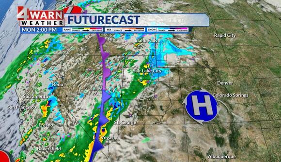
The Wasatch Mountains north of I-80 are expected to see the heaviest snowfall with a Winter Weather Advisory in place through early Tuesday morning. Heavy snowfall is expected with roughly 5-10″ forecast with the highest amounts along the Bear River Range where up to 15″ could fall.
Temperatures will remain in the mid to upper 40s along the Wasatch Front with breezy winds. Strong winds along the western half of the state are expected to taper off late morning. A Wind Advisory is forecast to remain in place through 11 a.m. this morning from southwest Utah stretching north into the West Desert and the Tooele Valley. Winds of 20-30 mph remain forecast with gusts to 50 mph. Impacts to high-profile vehicles traveling along I-80 are possible.