
SALT LAKE CITY ( ABC4 ) — Calmer skies are slowly settling in this weekend with a lingering chance of wet weather.
There will still be a chance of lingering snow showers through tomorrow with the bulk of any snow favoring the high country. By this afternoon most spots outside of the high country will see a mix of sun and clouds with temperatures near or even slightly cooler thanks to a northerly flow.
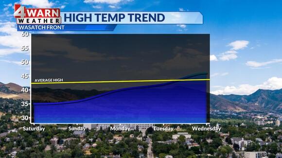
The end of the weekend will bring mostly sunny skies with below-average temperatures. Each day through the first half of next week will bring a mix of sun and clouds across Utah as we start a slow and steady warming trend.
With fresh snow in the high country, it’s important to note, avalanche danger is spiking in the mountains. All mountain ranges in Utah carry at least a considerable to high risk of avalanche danger. It’s one of those days to avoid the backcountry and stick to the inbound areas of our ski resorts. You won’t want to travel below steep slopes for quite some time.
With more active weather coming our way, stay up to date with the latest both on-air and online with the ABC4, 4Warn Weather Team. We are Good4Utah!