
Tonight:
-
Colder Canadian air moves into eastern Washington, reaching the Lower Columbia Basin overnight.
-
Moisture from the central Pacific system enters SW Oregon as a warm front, lifting north into central Oregon.

PLAN YOUR DAY.jpg
Wednesday:
-
The central Pacific system undercuts the ridge, bringing precipitation.
-
Central Oregon experiences initial snow, with rising snow levels (3000 to 4500 feet) by afternoon.
-
The front progresses northward, spreading precipitation across the forecast area and stalling overnight.
-
Areas from Madras northward mainly experience snow, while lower elevations see a mix of rain and snow.
-
Wednesday Night – Thursday:
-
Elevations below 1000-1500 feet with a rain and snow mix, becoming mostly snow by Thursday morning.
-
A return to a mix is expected by midday and afternoon.
-
Precipitation along the stalled front decreases late Thursday, tapering off to showers by Thursday night.
-
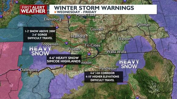
WWA.jpg
Snow Accumulations and Alerts:
-
The complex system leads to varying snow accumulations.
-
Winter Storm Watches, Warnings, and advisories are in effect, especially in the Oregon and southern Washington Cascades.
-
Travel difficulties are possible from White Pass southward.